Circling the Abyss
I love to study maps and read about routes. One day a few months ago I was browsing around the 14ers.com website and got an idea for a run I wanted to do. Actually it was more of a ridge scramble than run, but that just made it that much better in my mind. I would take the Abyss Lake trail starting at the trailhead on Guanella Pass Road, summit Bierstadt via the East Ridge route, then cross The Sawtooth, summit Evans, descend the Bowling Alley, and close the loop. Then back to the trailhead.

Route starts and ends at the Abyss Lake Trailhead which is slightly off the map in the bottom left corner.
I had never climbed Bierstadt or Evans (arguably two of the easiest and most popular 14,000′ Colorado peaks), and this looked like an excellent non-traditional approach. So when I suddenly found myself with a day to play, I knew right where to go.
It was Labor Day and I didn’t find out until late Sunday night that I would be going, which ruled out partnering up with anyone. This would be solo. Also, since it was likely to be a high-quality route that probably had never been done before, I documented the run (with photos of the stopwatch at key points) to establish a baseline FKT (Fastest Known Time).

Filled out the permit...
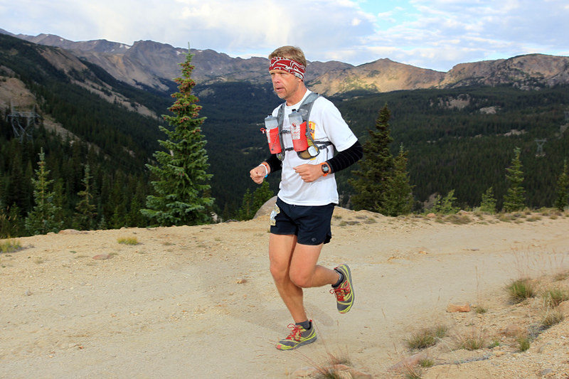
After a little paperwork, it was time to go. I was starting just before 7am, temp was around 36 degrees. Pretty cold. Weather was a big concern because the forecast wasn’t that great. Thunderstorms were likely. I was prepared with several bail-out options that I could use if things got too bad.
Other than a 1.5 mile jog on the Friday before Labor Day to see if my legs still worked, this would be my first run since finishing the Leadville 100 two weeks ago. I had doubts about how I would do, and gave myself less than a 20% chance of completing the whole route. In the itinerary I left with my wife, I detailed plan A as just going to Abyss Lake and back. Plan B was going further to Bierstadt, then descending back to the lake. Plan C was the whole enchilada. I like enchiladas…

Better put that camera away and start running!
The first four miles of the trail climbed gradually through a thick aspen/pine forest. Fall is definitely underway in the high country.

Trail was pretty wet from rain the night before.
A few stream crossings slowed things down a little, but were a nice change of pace. Managed to keep the feet dry.

These logs had frost on them and were VERY slippery.
Soon I came to the day’s first major trail intersection. I was relieved to see it well marked as I knew this was a key junction.

About 1,500 feet of climbing to this point. Right around 11,000' elevation here.
There was another similar junction in a quarter of a mile, then I switchbacked up a longer climb to reach the first lake of the day.

The well-defined trail would soon disappear into the thick willows.
I would end up a little off-route trying to navigate through the very thick brush, and multiple small streams. The willows were over head high and impossible to break through, so I just followed seams in the growth and did the best I could. Thankfully it was fairly short. I did a much better job on the way back. I half-expected to spook a moose out of there, but didn’t see any.

The trail improved for a while after that, but soon deteriorated into more willows. These were easily navigated by hopping rocks up a stream until an exit could be found.

Seeing the granite cliffs made me wish I had some climbing gear.

Soon I was at the entrance to the Abyss Lake cirque. The weather looked great so far, and I was feeling good.

You can see the trail in the center of the photo. After making it to the shadow line up ahead, I would make a sharp left and abandon the trail to start climbing the east ridge of Mt. Bierstadt.
You can see from the elevation profile that mile 8 is where the real climbing begins. Straight up to the top of the ridge. Very steep.

It took about 30 minutes to climb the half mile to the top of the ridgeline. Slow going would be the theme from here on.
I worked hard for the 30 minutes it took to gain the ridgeline. Grabbing rocks, clumps of grass, anything that was handy to aid in the ascent.

The trailhead is just below the "-". I followed the valley up the left side of the picture before swinging back west and scrambling up the ridge.
Now it was time to face the first technical difficulty. I had to negotiate up and over the hump in the ridge. I was a little nervous about it from reading the route description, but it turned out great and I had fun going up and over.

Follow the grassy ledge in the center until it disappears, then make a hard 180 and ascend diagonally up to the ridgetop. Then go up and over following the shadowed line right in the center of the knob in the photo.
I came across a few other folks on this section and motored on by. They had started on the Mount Evans road and were doing a shortened version of my route. It was fun to be going solo and able to move a whatever speed I wanted. It seemed that those with partners would get hung up in endless debates on which way to go in the spots that weren’t obvious. I was able to just climb through.

Look very closely and you can see a guy in a blue shirt and white hat on the left side of the ridge. He wasn't very far ahead of me - gives you a good feel for the scale of this place. HUGE!
A few more scrambles and lots of rock hopping and I got a clear view of Abyss Lake down below. Not a very big lake. The Sawtooth is the ridge above the lake to the left. That is where I was headed after topping out on Bierstadt.
 Abyss Puddle?
Rocks, rocks, rocks. Hop, hike, hop.

BFPoR - Big Freaking Pile of Rock. Final push to the Bierstadt summit.

I hit the summit of Mt. Bierstadt (14,060′) after an hour on the ridge.

There were about 25 other people on top who had climbed up the standard route from the west.
There were a lot of people on the summit. Noticing that my once blue skies were now more white and grey, I took off after less than 2 minutes. Not even halfway done yet.

Amazing country. Never get tired of it. Great view of Grays & Torreys in the center of the picture.
Time to tackle The Sawtooth. Basically follow steep intermittent trail through the rocks to the low point in the ridge. Climb up a good 50′ or so of class 3 stuff, then cross over and work your way across some exposed ledges to gain the ridge coming off of Evans.

Slowest mile of the day. 1:08 to make it from here to the ridge in the distance. Not used to measuring my speed in "hours per mile".
After descending about 1,000′ I came across two women that were trying to take a ‘shortcut’ back to Guanella Pass and were asking me for route info. They were horribly mistaken about their directions, and were heading over to the west side of the ridge which was nothing but huge cliffs. I told them they had to go straight back up to the summit and down the west ridge. Trying to go around the peak would not work. Granted, going back up to the top would suck – but it was really the only safe option.

Looking back at Bierstadt, 2/3 of the way across The Sawtooth.
There was a group of 4-5 guys up ahead of me that were taking a higher line across the ridge. It was apparent from the way they were talking that they weren’t too sure about what they were doing. I knew I had to beat them to the crux climbing section or I would be stuck as they debated every move. I hurried up and just pulled it off, clear sailing ahead.
Next up was the ledge exit. This went fine and I was done with my first crossing of The Sawtooth.

Somewhat exposed. Looks maybe a little worse in the photo? Didn't seem too bad while I was on it.

More great views looking north.
Now for the big mistake of the day (those girls could laugh at me now I guess). Finally free of the ridge, I was excited for the chance to run again for the first time in 2.5 hours. I put on the iPod and started following the cairns marking the trail across the broad tundra thinking I was really making good progress now, and keeping a watchful eye on the gathering clouds.

Follow the piles of rocks. Time to run again!
I headed in the direction of the next high point along the ridge, shown in the next photo. I should have made a hard right hand turn which would have taken me directly to Mt. Evans.

I ended up going over Mt. Spalding (13,800') and down the other side a while before realizing my error.
Once Summit Lake came into view, I knew I had screwed up. I should be looking at it from the south. Instead I was on the north side. Crap. This little detour cost me about 45 minutes.

Mt. Evans is the highest point on the left. I was more than just a little bit off-course.
I was pretty disgusted with myself, but nothing to do except run back and go the right way. That spoiled my idea of establishing a FKT, but that would be ok. It was mostly turning into a route-finding and picture-taking day. I’ll come back and do it for speed another time.

Back on route now, looking over Abyss Lake at Bierstadt and the ridge I had been on under blue skies earlier in the day.
I finally made it to the summit of Mt. Evans (14,264′), along with about a hundred other folks.

The proper view of Summit Lake from the top of Mt. Evans. D'oh!
It turns out that today was the last day for the road to be open (highest paved road in North America, comes to within a couple hundred feet of the summit). It was a madhouse with with Harleys, Hummers, vans, cyclists, etc. all trying to find a place to park.

Very surreal to be pretty much hiking alone for 6 hours and then pop into the middle of a circus.
The weather was generally holding, though there were storms all around. Time to head down! I had about 5,000′ of elevation to lose to get back to the trailhead.

Eye on prize. Still a long way to go.
The last challenge of the day is an 800′ gully called the Bowling Alley (picture bowling ball sized rocks flying down a mountain and you get the idea). This late in the day, I was the only person in sight, so I had less to worry about with the rock fall from (or onto) others.

Looking back up the Bowling Alley.
I was out of water at this point. I had some purification solution with me, but opted to stick it out for 2 more hours and just get done.

Hailed briefly while the sun was shining.
I hit the final trail junction right at 9 hours, so the goal turned to finishing it off under 10.

Couldn't remember how far it was from here to the trailhead, so I just ran hard the whole way.

Made it.
What a great day! I thought to myself over and over again how awesome it was to be in good enough shape to actually enjoy doing something like this. It was the reward for all of those day-in day-out runs where you’d rather be doing something else.
This route was fantastic. A true Colorado epic. A great mix of running and scrambling. I would highly recommend it, and can’t wait to do it again. I think if I skip the side trip to Spalding and cut back on the photos, I can drop the time close to 8 hours. At any rate, it’ll sure be fun to try!

Done.
Photo album here.
Posted on September 20, 2009, in run. Bookmark the permalink. 8 Comments.


Right on. I had to show Jenny and her response was two fold… “Wow that is georgous!” and “What is his family doing?” Loved all of the pictures, and really brings it to live. Makes me wanna.
Yeah, it was purty. The family was fine, no worries. They were all whupped from me taking them around having fun all over Denver earlier in the weekend.
Yes, I need to be careful with my wordings. You are a great dad, and Jenny is a great wife. Didn’t mean to make that sound opposite of those two things.
Holy crow on some of these pics. Are you doing stuff to enhance the shots that you have not made BW?
Epic epic trip.
Ya, I’m busted. Just some basic stuff with Picasa. My camera is tough (dropproof/waterproof/freezeproof – perfect for trail running) but the unedited shots are pretty flat. A little tweaking and they really pop, though.
Chris what a wonderful day you had and the pictures are great. We are proud of you and hope you will always be safe. Of course I am Mom and I worry. Love to you Mom and Dad
You are stinkin’ nuts!!! I’m glad you didn’t fall off a cliff or twist your ankle on all those rocks. Loved the pictures. You are amazing.
What is new?