Monthly Archives: September 2009
Circling the Abyss
I love to study maps and read about routes. One day a few months ago I was browsing around the 14ers.com website and got an idea for a run I wanted to do. Actually it was more of a ridge scramble than run, but that just made it that much better in my mind. I would take the Abyss Lake trail starting at the trailhead on Guanella Pass Road, summit Bierstadt via the East Ridge route, then cross The Sawtooth, summit Evans, descend the Bowling Alley, and close the loop. Then back to the trailhead.

Route starts and ends at the Abyss Lake Trailhead which is slightly off the map in the bottom left corner.
I had never climbed Bierstadt or Evans (arguably two of the easiest and most popular 14,000′ Colorado peaks), and this looked like an excellent non-traditional approach. So when I suddenly found myself with a day to play, I knew right where to go.
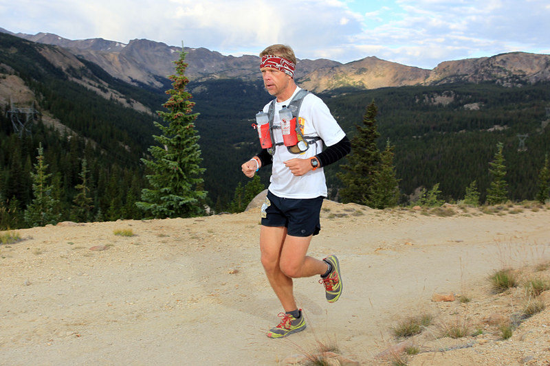
It was Labor Day and I didn’t find out until late Sunday night that I would be going, which ruled out partnering up with anyone. This would be solo. Also, since it was likely to be a high-quality route that probably had never been done before, I documented the run (with photos of the stopwatch at key points) to establish a baseline FKT (Fastest Known Time).

Filled out the permit...
After a little paperwork, it was time to go. I was starting just before 7am, temp was around 36 degrees. Pretty cold. Weather was a big concern because the forecast wasn’t that great. Thunderstorms were likely. I was prepared with several bail-out options that I could use if things got too bad.
Other than a 1.5 mile jog on the Friday before Labor Day to see if my legs still worked, this would be my first run since finishing the Leadville 100 two weeks ago. I had doubts about how I would do, and gave myself less than a 20% chance of completing the whole route. In the itinerary I left with my wife, I detailed plan A as just going to Abyss Lake and back. Plan B was going further to Bierstadt, then descending back to the lake. Plan C was the whole enchilada. I like enchiladas…

Better put that camera away and start running!
The first four miles of the trail climbed gradually through a thick aspen/pine forest. Fall is definitely underway in the high country.

Trail was pretty wet from rain the night before.
A few stream crossings slowed things down a little, but were a nice change of pace. Managed to keep the feet dry.

These logs had frost on them and were VERY slippery.
Soon I came to the day’s first major trail intersection. I was relieved to see it well marked as I knew this was a key junction.

About 1,500 feet of climbing to this point. Right around 11,000' elevation here.
There was another similar junction in a quarter of a mile, then I switchbacked up a longer climb to reach the first lake of the day.

The well-defined trail would soon disappear into the thick willows.
I would end up a little off-route trying to navigate through the very thick brush, and multiple small streams. The willows were over head high and impossible to break through, so I just followed seams in the growth and did the best I could. Thankfully it was fairly short. I did a much better job on the way back. I half-expected to spook a moose out of there, but didn’t see any.

The trail improved for a while after that, but soon deteriorated into more willows. These were easily navigated by hopping rocks up a stream until an exit could be found.

Seeing the granite cliffs made me wish I had some climbing gear.

Soon I was at the entrance to the Abyss Lake cirque. The weather looked great so far, and I was feeling good.

You can see the trail in the center of the photo. After making it to the shadow line up ahead, I would make a sharp left and abandon the trail to start climbing the east ridge of Mt. Bierstadt.
You can see from the elevation profile that mile 8 is where the real climbing begins. Straight up to the top of the ridge. Very steep.

It took about 30 minutes to climb the half mile to the top of the ridgeline. Slow going would be the theme from here on.
I worked hard for the 30 minutes it took to gain the ridgeline. Grabbing rocks, clumps of grass, anything that was handy to aid in the ascent.

The trailhead is just below the "-". I followed the valley up the left side of the picture before swinging back west and scrambling up the ridge.
Now it was time to face the first technical difficulty. I had to negotiate up and over the hump in the ridge. I was a little nervous about it from reading the route description, but it turned out great and I had fun going up and over.

Follow the grassy ledge in the center until it disappears, then make a hard 180 and ascend diagonally up to the ridgetop. Then go up and over following the shadowed line right in the center of the knob in the photo.
I came across a few other folks on this section and motored on by. They had started on the Mount Evans road and were doing a shortened version of my route. It was fun to be going solo and able to move a whatever speed I wanted. It seemed that those with partners would get hung up in endless debates on which way to go in the spots that weren’t obvious. I was able to just climb through.

Look very closely and you can see a guy in a blue shirt and white hat on the left side of the ridge. He wasn't very far ahead of me - gives you a good feel for the scale of this place. HUGE!
A few more scrambles and lots of rock hopping and I got a clear view of Abyss Lake down below. Not a very big lake. The Sawtooth is the ridge above the lake to the left. That is where I was headed after topping out on Bierstadt.
 Abyss Puddle?
Rocks, rocks, rocks. Hop, hike, hop.

BFPoR - Big Freaking Pile of Rock. Final push to the Bierstadt summit.

I hit the summit of Mt. Bierstadt (14,060′) after an hour on the ridge.

There were about 25 other people on top who had climbed up the standard route from the west.
There were a lot of people on the summit. Noticing that my once blue skies were now more white and grey, I took off after less than 2 minutes. Not even halfway done yet.

Amazing country. Never get tired of it. Great view of Grays & Torreys in the center of the picture.
Time to tackle The Sawtooth. Basically follow steep intermittent trail through the rocks to the low point in the ridge. Climb up a good 50′ or so of class 3 stuff, then cross over and work your way across some exposed ledges to gain the ridge coming off of Evans.

Slowest mile of the day. 1:08 to make it from here to the ridge in the distance. Not used to measuring my speed in "hours per mile".
After descending about 1,000′ I came across two women that were trying to take a ‘shortcut’ back to Guanella Pass and were asking me for route info. They were horribly mistaken about their directions, and were heading over to the west side of the ridge which was nothing but huge cliffs. I told them they had to go straight back up to the summit and down the west ridge. Trying to go around the peak would not work. Granted, going back up to the top would suck – but it was really the only safe option.

Looking back at Bierstadt, 2/3 of the way across The Sawtooth.
There was a group of 4-5 guys up ahead of me that were taking a higher line across the ridge. It was apparent from the way they were talking that they weren’t too sure about what they were doing. I knew I had to beat them to the crux climbing section or I would be stuck as they debated every move. I hurried up and just pulled it off, clear sailing ahead.
Next up was the ledge exit. This went fine and I was done with my first crossing of The Sawtooth.

Somewhat exposed. Looks maybe a little worse in the photo? Didn't seem too bad while I was on it.

More great views looking north.
Now for the big mistake of the day (those girls could laugh at me now I guess). Finally free of the ridge, I was excited for the chance to run again for the first time in 2.5 hours. I put on the iPod and started following the cairns marking the trail across the broad tundra thinking I was really making good progress now, and keeping a watchful eye on the gathering clouds.

Follow the piles of rocks. Time to run again!
I headed in the direction of the next high point along the ridge, shown in the next photo. I should have made a hard right hand turn which would have taken me directly to Mt. Evans.

I ended up going over Mt. Spalding (13,800') and down the other side a while before realizing my error.
Once Summit Lake came into view, I knew I had screwed up. I should be looking at it from the south. Instead I was on the north side. Crap. This little detour cost me about 45 minutes.

Mt. Evans is the highest point on the left. I was more than just a little bit off-course.
I was pretty disgusted with myself, but nothing to do except run back and go the right way. That spoiled my idea of establishing a FKT, but that would be ok. It was mostly turning into a route-finding and picture-taking day. I’ll come back and do it for speed another time.

Back on route now, looking over Abyss Lake at Bierstadt and the ridge I had been on under blue skies earlier in the day.
I finally made it to the summit of Mt. Evans (14,264′), along with about a hundred other folks.

The proper view of Summit Lake from the top of Mt. Evans. D'oh!
It turns out that today was the last day for the road to be open (highest paved road in North America, comes to within a couple hundred feet of the summit). It was a madhouse with with Harleys, Hummers, vans, cyclists, etc. all trying to find a place to park.

Very surreal to be pretty much hiking alone for 6 hours and then pop into the middle of a circus.
The weather was generally holding, though there were storms all around. Time to head down! I had about 5,000′ of elevation to lose to get back to the trailhead.

Eye on prize. Still a long way to go.
The last challenge of the day is an 800′ gully called the Bowling Alley (picture bowling ball sized rocks flying down a mountain and you get the idea). This late in the day, I was the only person in sight, so I had less to worry about with the rock fall from (or onto) others.

Looking back up the Bowling Alley.
I was out of water at this point. I had some purification solution with me, but opted to stick it out for 2 more hours and just get done.

Hailed briefly while the sun was shining.
I hit the final trail junction right at 9 hours, so the goal turned to finishing it off under 10.

Couldn't remember how far it was from here to the trailhead, so I just ran hard the whole way.

Made it.
What a great day! I thought to myself over and over again how awesome it was to be in good enough shape to actually enjoy doing something like this. It was the reward for all of those day-in day-out runs where you’d rather be doing something else.
This route was fantastic. A true Colorado epic. A great mix of running and scrambling. I would highly recommend it, and can’t wait to do it again. I think if I skip the side trip to Spalding and cut back on the photos, I can drop the time close to 8 hours. At any rate, it’ll sure be fun to try!

Done.
Photo album here.
Race Report: 2009 Rox Trot
Hopped in the neighborhood 5k this morning. Pushed Jessica in the stroller and took 3rd place out of 50 or so. Our time was only around 26 minutes, but there was a lot of climbing – especially on the way back to the finish. I held my heart rate over 180 for the last 5 minutes of the race, maxing out at 188. Ouch! Pushing 50+ pounds of stroller up a hill like that will really make you work!!
After the race I asked Jessica if Daddy was breathing kind of loud. She replied, “You were hurting my ears!”
Race Report: 2009 Leadville Trail 100
THUMP – THUMP – THUMP – THUMP. Long strides carry me quickly down the rocky jeep road. Landing gear extended, flaps down. I’m starting the final approach to Twin Lakes. It’s coming up on high noon. Sweat pours from my skin as the Sun’s intense rays do their best to wrap around my body and wring out every last drop of moisture. Legs that have been on the go for over seven hours are feeling tired. Tired of jogging. Tired of holding back. Two runners that I had been following take a wrong turn on a steep switchback, and though quickly corrected, my calm and methodical approach to the day that I had adhered to so carefully gets kicked to the curb for an instant.
I jump into the lead of our little group. And RUN.
Completely letting go of the reins.
The muffled clanging of a cowbell fights its way through a thick blanket of pine branches to reach my ear. Like pouring gasoline on a fire, the sound drives my legs harder. Faster. Then the honk of a car horn. Cheering. More scraping and crunching of shoes on dirt and rocks trying to simultaneously propel and maintain control down the steep grade. Quiet again as the trail veers away from the sounds of the aid station. Just breathing and footsteps now. Was it a mirage? Another switchback, heading east. Clanging, honking, cheering getting louder with every step. The bucket of adrenaline inside my chest lay on its side. Contents flowing outward in all directions carrying a dam-bursting rush of electric current to my extremeties.
I was flying!
A final stride launches me out of the trees onto a bluff high above the aid station. A sea of cars, tents, bikes, dogs, runners, volunteers, crews, and spectators spreads out below. The yelling-clapping-clanging-honking is dumped into the blender that is my brain and gets whipped into more adrenaline. My visceral reaction is to of course run faster. This output increases the noise; the crowd, used to seeing staggering heat-zapped zombies, senses they have a live one here. Cheers fueling adrenaline, adrenaline fueling cheers. Happy to stay upright as I negotiate the final steep switchbacks, I cruise sweaty and breathless into the mass of people and find the entrance to the aid station. Six! Four! Zero! Checking in.
This is the Leadville Trail 100.
A race that is a juxtaposition of shoulder bumping and leapfrogging on dark crowded trails, to vast stretches of lonely territory without another soul in sight. From Carnival, to Walden Pond. Fast cruising on level pavement, followed by climbing up pitches so steep your toe joints will ache from trying to claw into the dirt as your hands reach for nearby aspen saplings to assist with the ascent . Moving so slowly it feels like the first sprouts of moss are taking hold on your northern aspect. There is heat, if 81 degrees qualifies. I am now one hundred percent certain that it does at over 12,000 feet in elevation, with no cloud cover, and no breeze. There are rivers to wade through, and there is dust. And precious little air to fill your lungs.
The reward for making it this far in the race is to keep your back turned on the town of Leadville, now some 40 miles behind you, and run towards the base of the biggest climb of the day.
The road leading me to this point was a LOT longer than 40 miles. More like six thousand. When I started running two and half years ago, finishing a 100 mile race was the goal. I checked that off the list in fairly short order that same year with a 32+ hour grind through the mountains of Idaho. My first experience with a rolled ankle would see me limp along during a freezing snowstorm taking 7 hours to cover the last 15 miles. While elated to have my first 100 mile finish, I was left wanting and knew I could do better.
Enter Leadville.
When folks in Colorado hear that you run ultras, Leadville becomes the #1 topic of conversation. At least here on the Front Range, Leadville is the ultramarathon. Living only 2 hours from the course, it seemed a logical choice for my next 100 mile attempt and I found myself at the starting line in 2008. Somewhat undertrained, probably a little over-raced, and not as prepared as I should have been. I thought I could just cruise through and finish no problem. Handily snagging the BIG buckle for a sub-25 hour finish along the way.
I gave it a shot, ultimately dropping out at mile 77 for a multitude of reasons. All of which seemed really good until I realized I still had 9 hours on the clock. I hadn’t done my homework. I trained hard on climbs and hills, but failed to run really long distances. I didn’t practice running at night. When crunch-time arrived, I convinced myself I was more interested in a good finish, rather than just a finish. What a crock! That kind of attitude couldn’t be further from the spirit of ultras that had drawn me into doing these races since I had first become aware of their existence. I had given it damn near everything, but not quite everything. As I squirmed in the front seat of my car in the darkness after dropping out, trying to sleep with massively aching legs and a broken spirit, freezing cold as the snow and rain pelted the windshield… scratch that. As the snow and rain pelted the runners out in the night… still making their way towards the finish line in what was, by general consensus, the worst weather in the race’s 25 year history, giving it everything. I had plenty of time to think. I knew I would be back. Stronger. Faster. Lighter. And with a much improved attitude. I would show the race the respect it deserved and demanded. I would do my homework. I would train harder than I ever had in my life.
I did.
After some time off due to injury rehab, and still far from 100% healthy, I set out on my journey of training for Leadville 2009. Due to my strained achilles, I couldn’t do much climbing or speed work. What I could do is run at a moderate pace for a really long time. That became the foundation of my new training philosophy:
Beat the crap out of your body, as gently as possible.
I piled up run after run in the 20 to 35 mile range. Always two, and sometimes three per week. At night, or in the rain. In the heat of the day, or while tired from a previous run or long day at work. Mostly alone, my iPod providing the soundtrack. It worked. I felt myself getting stronger as the weeks went by and running for hours on end at 9:30 pace became routine. I did my homework. Making three trips to Leadville to run parts of the course. I practiced taking in the calories I would need to sustain myself over 100 miles, tested different means of carrying water, rotated through many pairs of shoe and sock combinations. All in an effort to arrive at the starting line as prepared as I could possibly be. At all times with the image of my arm extended into the darkness while my wristband was cut off last year flashing into my mind.
1:57
The Indiglo button on my watch let me know that I had 25 minutes until the alarm would sound. Sleep had not come tonight. A dull headache from the altitude had prevented me from going under until sheer exhaustion finally prevailed at two in the morning. At 2:22 I disabled all three alarms before they went off. Shoved my tent and sleeping bag into the back of my car, and coasted out of the campground. It was showtime.
The party was in full swing as I parked just off the main road through town and made my way to the starting line to sign in. Music blasted through the streets. Lights and generators buzzed. Runners and crew members milled about talking in excited voices that were several decibels higher than necessary, like people get after two or three beers in their system. I was guilty of the loud voice as well, greeting friends old and new, wishing each other well, soaking up the vibes.
Gone were the rain and freezing temperatures of last year. It was a beautiful morning with a perfectly black sky. Standing in the 6th row, I switched on my headlamp and stared at the spot of light it made at my feet. Feet that would start moving with the sound of a shotgun blast and would not come to a final stop until covering 100 miles to get back to this exact same place, hopefully before sunrise the next day.

Race start. Photo credit: Rob O'Dea
A deep breath. Shake out the arms. Rotate the head to loosen the neck muscles. Relax. Eyes flicking to the digital clock on the nearby scaffolding every few seconds. Tick. Tick. Tick.
BOOM!
With a huge yawp 504 pairs of feet started running west. Out of town. Into the night. Into the unknown.
Immediately my legs adopted the familiar trot that had been the norm for many weeks now. The first aid station was 13.5 miles away, and I would arrive there shortly after dawn. There was no hurry at this point and I enjoyed running in the darkness for many miles along the shoreline of Turquoise Lake. Making sure to look back when I had the chance and take in the magnificent scene created by hundreds of lights snaking their way along the path in a single-file line.
Soon the May Queen campground came into view, meaning just a short time to make the aid station. I arrived in 2:20, eight minutes faster than last year, but at an easier effort. Just right. All systems go.
I bounded across the wooden bridge that signals the start of the Colorado Trail section. The same spot where I had taken my family hiking two weeks earlier for our last summer outing before school started. My thoughts drifted back to that day, and especially to the determination of my youngest daughter to climb the steepest parts of the trail on her own, with just a single handhold from dad. Now six years old, born with Spina Bifida, she wears molded plastic braces on her lower legs to assist with walking and balance. In all of our previous hikes, I would carry her up the hills and over the rocky parts. That day was different. She was going into first grade after all, and would do the climbs on her own now – thank you very much. I couldn’t help smiling proudly as she held my hand and we made our way steadily up the very steep and long hill that was the final obstacle between us and our destination of Timberline Lake. Passing other hikers that were needing a break to catch their breath. You go, girl.

Jessica hiking her way
I began the climb up Sugarloaf Pass in the light but as yet sunless sky. One thing was readily apparent, today would be very hot and very dry. The normal mountaintop contest for domination between Sun and Clouds would not be in the cards, giving the Sun an uncontested victory for now. The next few hours passed in a consistent fashion. Gel or bloks every 30 minutes, salt capsule every 60, suck down plenty of water – but not too much. Hike, run, jog, repeat. I was 13 minutes ahead of last year’s pace at the next aid station (Fish Hatchery – mile 23.5), giving the wooden sign there a confident wink as I exited and imagining the moment later that night when I would run past it again at mile 76.5 to pick up where I had left off last year.

15 down, 85 to go.
With some time to kill the evening before the race, I had driven out to this location to sit and think for a while. I pictured what it would look like the next day, full of activity and sounds. With dreams being crushed for some, and fulfilled for others. I pictured myself running strongly past that sign, quickly refilling my supplies, and then pressing onward through the night towards the finish line.

You're not getting my wristband this year...
I also spent some time thinking about the four soldiers that had been killed in a helicopter crash earlier in the week on the mountain high above where I sat. Thinking of them and so many others who truly had given their all – allowing me to be here doing what I love. The guys who died in the Blackhawk were part of an elite group out of Fort Campbell, Kentucky called the Night Stalkers. Assigned to the 160th Special Operations Aviation Regiment. With them in mind, and also for the more traditional meaning of the word, I took a sharpie out of my bag and wrote SOAR across the knuckles on my left hand where I could look at it during hard times in the race and draw strength. And keep perspective.

After my adrenaline enhanced trip through the Twin Lakes aid station, it was time for a system check. Mile 40. Calories? Decent. Hydration? Trying, but falling behind. Salt? Seems ok. No cramping. Stomach? On the edge at times, still hanging in there. Pace? We’ll see.
Hope Pass.
Pope Hass. Opehay Asspay. Any way you slice it, this climb is tough.
Taking just over 7 hours to come this far, I would need another 7 hours to cover the next 20 miles to Winfield and back. It was hot and the trail is very steep. I felt terrible at first, but knew my body just needed a while to adapt to the new pace and different type of effort. Slowly I climbed, feeling like I was dragging an anchor behind me. Trying to find the sweet spot between pushing hard enough, and pushing too hard. I knew that I was now 40 minutes to the good compared to last year’s pace, and if I could just break even on this next section I would be fine. This is when thoughts of The Buckle started to creep into my head.
I debated in the days leading up to the race about whether or not to ‘go for it’. I really didn’t have any prior indication to make me confident that I could do it. Just a feeling that I could run at about 25 hour pace. I decided that I was at least in good enough shape to take a shot at it. The plan was to run conservatively and see if I could make it to the halfway point in 11 hours, giving me 14 for the return trip. Many people advise going out in 10, but I knew 11 would be the way to go for me. It would sometimes make for a tense day as I kept hovering just above or just below the splits I had calculated, and I would have preferred having more of a cushion, but it sure made things interesting. I hit Winfield in 11:02 and in 90th place – working my way up from 239 at the first aid station. Game on.
I lost a few spots on the climb up the back side of Hope Pass. It’s just so incredibly steep, I don’t worry about what others do and try to manage it the best that I can. Coming over the pass is such an incredible sight – about a half mile below you can see the minimal aid station, with tents and smoke from a campfire. Llamas graze out in the open, their work done the previous day hauling all of the gear up to that point. It would be a great place to hang out and linger, but the finish line awaits. Leadville is a barely visible smudge at the base of some mountains way out on the horizon. A jaw-dropping sight, really, but one you don’t want to dwell on too long as the cold reality sets in. Long way to go. Best to keep moving.
I passed everyone that had beaten me up the climb as I ran the long and steep descent back to Twin Lakes. I caught up to Hans, the retired doctor from Germany who now travels the country running 100 mile races. “Hans! What number is today’s race?”. “One Hundred Thirteen”, came the accented reply. Awesome.
Coming into Twin Lakes for the second time felt nothing like the rush I had experienced earlier in the day. There was still a big crowd, and it was great to hear the cheers – but I was all business. Mile 60. 14:38 elapsed. As the sun was going behind the mountains, I took what I had planned on being my longest stop. Time to get ready for the night ahead. Finished with river crossings now, change shoes and socks. Thank you feet for holding up so well. A fresh shirt, gulp down a cup of noodles. Two cups of coke. Headlamp, spare batteries, iPod. Yep, yep, yep. Six! Four! Zero! Checking out.
Another long climb awaits, but this one is more gradual in nature. Cool evening air, and forested singletrack. What a great place to be! With over 200 runners dropping out of the race up to this point, human contact was much less frequent than earlier in the day. With no crew waiting on me, or anyone muling my gear, it was time to put on the tunes and cruise. Stars dotted the sky while my headlamp cast a beam of white light down the tunnel of trees.
I looked forward to the miles of gradual descent that were ahead, knowing that as bad as I sucked climbing over Hope Pass, this is where I would excel. This is what I had trained for. Time could be made up, if you had the legs. While many people began to walk more and more frequently, even on perfectly runnable terrain, I did the opposite. Long stretches of running broken only by a stop at an aid station or a quick break to water the plants.
I ran well for a long time, but faltered a little as I reached pavement again. To be expected, I guess, after moving under your own power for such a long time. I walked for a few minutes and then gathered myself for one long running push back to the Fish Hatchery aid station. I checked my watch as I arrived. The experience of a night-time training run covering the final 23 miles a couple of weeks earlier told me that I wanted at least 6 hours to finish from here. I arrived at 18:42 elapsed time.
The sub-25 buckle was still within reach, but I didn’t have any slack to play with.
As I checked in to the aid station, I heard someone ask if I wanted a pacer. I declined, but the offer came again. I shrugged and said, “Sure, I’ll give you a tour of the final miles”. Jim had flown out from Minnesota to pace his friend and training partner, but his friend had suffered an injury taking him out at mile 40. So, there he was all dressed up and nowhere to go, so to speak. He had never paced anyone before. I had never used a pacer in 14 previous ultras. We were a good match.
The last major obstacle was soon in our sights. A big, steep hill known as powerline. I struggled, taking 1:20 to do the climb that was normally done in 50 minutes without too much trouble on fresh legs. I kissed the idea of getting the big buckle goodbye. Happy to have come this far and gotten this close. I felt sorry for Jim, stuck with a slowly moving slug like me.
Once we crested the top, I started jogging. It only lasted a few feet, but then I walked a few seconds and tried again. It took several tries, going a little longer on each one, but soon I was loosened up and cruising down the trail again. Nice! It was good to have Jim’s company and we talked the miles away, hitting the final aid station with just over 3 hours remaining to come in under 25. 13.5 miles with a fair bit of climbing. Not going to make it, I said, but let’s see how close I can get.
Then we did the math with six miles to go. Hey, this just might be possible after all. I sped up and was running steady on the long straight road taking us back to the railroad tracks outside of town. Every minute or two I would speed up a little more until we reached the bottom of The Boulevard. 3 miles left, all uphill. Starting out steep and rocky, the grade mellows and the surface improves. Dreaded by most, I loved it. I ran it all as hard as I could. Jim ran 5 feet ahead and just off to the side, keying off my speed and never letting me close the gap. I was still going faster, now in full stride thinking there was no way I was putting myself through all of this and missing my target by just a few minutes. I smiled as Jim’s breathing became more labored, his Minnesota lungs working to hold the pace at 10,000 feet.
With two miles to go, I surged even harder. Like a boat planing across the water, my feet felt as though they were barely even touching the ground. It was amazing. I ran all the way to the line, punching the air and letting out a yell as I broke the tape they held out for every finisher. That felt good! 24:44. 55th place.
High fives and hugs ensued. I was incredibly happy. The sky was as black as I had left it the day before. A perfect ending. I had buried the ghost of Leadville past, and danced on the grave.