2013 14er Trip – Day Three
From our home-base in Leadville, day three was a bit of a haul. We decided to head further south in an attempt to get out of the rainy weather. Shavano and Tabeguache were on the menu today. Our usual 4:30 wakeup got us down near the trailhead in time for another spectacular sunrise.

The trail rolls for a short while before becoming yet another steep grunt up through the trees. As many times as I do these hikes, I still shake my head at the size and steepness of these mountains sometimes. Soon we passed through a massive area of blown-down trees. I remembered reading about it a few years ago, and it was impressive to see up close.

Once we passed treeline, the trail became a straightforward ascent up to a small pass.


From the pass it was a few hundred vertical feet to the summit.


From the summit of Shavano we dropped to another saddle and made the climb up to Tabeguache. Took shots of the ‘summit monkeys’

and then a couple more…

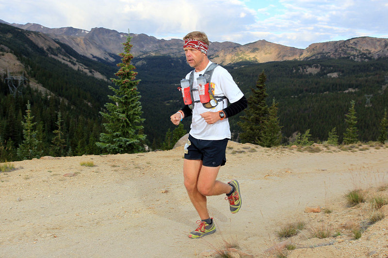
On the hike back to Shavano, a photo opportunity presented itself. The ensuing exchange highlighted the difference between my son just wanting a quick snapshot, and me planning the cover shoot of Outside magazine or something. Hey, I carried that big camera over all these mountains – I might as well get some good use out of it!
MB: Dad, will you take a picture of me up on those rocks?
CB: Sure! Let’s see, I should get over there for the best light, maybe up a little higher for the horizon, you should stand there, look like this, and …, and …
MB: Well, it doesn’t have to be awesome. Err, at least not up to your level of awesome!
Hey, I’m cool with semi-awesome if you are.
I gotta say, Malcolm was a great sport with all of my picture taking during our hikes.

The nice weather allowed us to linger for a while when we returned back to the Shavano summit. Much to the delight of some curious marmots.

This ninja-squirrel demonstrated some cool moves.

Then it was all about getting back to the car.

A huge dumper of a thunderstorm unloaded on us with about a mile to go. All of a sudden the tired-leg plodding pace at the end of a long hike turned into an all-out run back to shelter. It was a great way to finish.
2013 14er Trip – Day Two
With a big day already in our legs, the plan for day two started to feel a little ambitious. We wanted to summit Missouri and Huron from the Missouri Gulch trailhead, which we estimated to be around 22 miles. I think we may have been able to do it, if not for the bad weather. In the end it worked out for the best and we still ended up with a solid 13 mile day and one summit.
We started before dawn and took notice that the clouds were already gathering. Those clouds made for a spectacular sunrise as we made our way up the first steep pitch of forested switchbacks.

The wildflowers were loving the cool and damp weather.

We climbed steadily, still not knowing if we were in for the full distance or not. Malcolm spotted a coyote hunting at above 12,000′ so we stopped and watched it for a while. I’ve never seen one this high before.


We saw other wildlife out and about in the brief period of sunshine.


A big push up a steep headwall got us to the ridgeline where we were treated to a great view of Mt. Huron across the valley.

The plan was to ascend the drainage on the right of the photo, then take the ridge to the summit.

As the skies turned more threatening, we decided to summit Missouri and then evaluate conditions. The route to the summit was a lot of fun. Just technical enough to keep things interesting. I really would like to have lingered on this one, but it started to rain and we stayed just long enough for a pic.

I stowed the big camera due to the weather, and we made quick work out of the return trip.

The terrain sloped steeply to the west and it was a constant battle to maintain grip on the ball-bearing surface. With the rain still coming down, we decided on making the descent to Clohesy Lake and evaluating our options from there. The next summit seemed close while looking at it from just across the valley, but we knew hours of bushwhacking and boulder hopping would be in our future. I dug the camera back out for this six shot vertical panorama.

The rain continued and then began to get worse as we neared the lake. We made the call to finish the hike by descending the 4 miles to the trailhead to close our loop and would leave Huron for another time.

As we neared the finish of our hike, we came to a fairly swift moving stream that we needed to cross. Even though it had been raining, our shoes were still not that wet and for some reason I thought it would be a good idea to take them off for the crossing. I have never done that before, and doubt if I ever will again. Stepping on small sharp rocks with bare feet in the freezing cold water was excruciating. As a bonus, I got to do even more hiking on rocks when I got to the other side in order to retrieve one of my shoes that I had thrown across. The other hit an embankment and had nearly tumbled back down into the river.
I finally made it back to the water’s edge, and took time to carefully clean off my feet. Getting my toe socks back on over wet feat was no small task. I laced everything up and started down the trail as Malcolm was finishing up. 10 seconds later I just started laughing. We were on an island! Ahead of us was another crossing about 5x longer than the one we had just traversed. Nice.

The shoes came off for this one, but when we were across I just jammed my feet in the socks without bothering to line up the toes and we trudged down the road for another mile before making it back to the car.
2013 14er Trip – Day One
Due to a shorter than normal vacation in early July, I ended up with the opportunity to take three days off work later in the month and head up to the high country. My son and I quickly threw some plans together and decided to keep home base in Leadville and venture out to some different peaks each day. This meant 4:45 wakeups each morning to get to the trailhead and hopefully beat the storms which usually show up later in the day.
On the way up after work on Tuesday I set the Copper to Leadville knee-driving FKT (the burrito needed two hands). If there ever is a knee-driving world championship, I’m in. #medalcontender

We spent the first evening high above town looking to capture the sun setting over Turquoise Lake. The sunset didn’t pan out, but I happened to catch some great Crepuscular Rays with one of the beams shining directly on the city.

Day one objective was Mt. of the Holy Cross. We would be taking the Halo Ridge route, which is a much longer (at least time-wise) approach to the summit. It traverses 2.5 miles of the ridge and without any trail. Almost all boulder-hopping.
The climb up Notch Mountain looked bad on the map, but turned out to be very nice with many switchbacks and a good trail. We paused for a bit to watch pika, marmots, and the camoflaged ptarmigans.


The columbine were in their full glory. This particular variation (there are over 70) is the Colorado state flower. Blue for the sky, white represents snow, and yellow represents gold mining.

Our first view of Holy Cross (named for the gullies that make a cross shape, especially evident when filled with snow) was magnificent. From this spot we could see the entire route to the summit. Kind of hard to tell in this shot, but the peak is actually over a mile away and 1,000′ higher than our location.

The scale of the entire area was amazing. I let Malcolm get a few minutes ahead of me and he turned into a tiny yellow spec on the ridge.

Even helicopters look microscopic from up here.

I snapped this panorama before I took off to catch up. The lake is called the Bowl of Tears. I probably shed a few later in the hike…

Hop. Hop. Hop. Long way from help. Don’t break an ankle…


We finally reached the summit after spending nearly 4 hours (stops and photos included) to travel the 2.5 miles along the ridge.


Thankfully the sketchy-looking clouds that began showing up at 8:30 never really amounted to anything. The descent was no picnic, but at least we were on a trail now.

It was great to get back to some vegetation after being on the rocks so long.

Normally with 14ers, once you summit it’s all downhill back the car. Holy Cross has a nasty little surprise with the 1,000′ climb over Half Moon Pass standing in your way. Malcolm absolutely crushed this climb and I barely held on. We were so glad to get to the top! After receiving some feedback from the home front that we were looking too serious in our summit photo, we risked cracking our faces and smiled for this one.

The trail back to the parking lot was a little slice of heaven.